FIRSMISS BLANCHEMER

surceneux
User
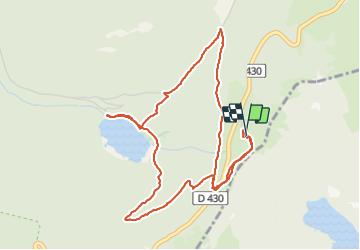

Length
5.3 km

Max alt
1214 m

Uphill gradient
238 m
Km-Effort
8.4 km

Min alt
988 m

Downhill gradient
232 m
Boucle
Yes
Creation date :
2021-09-13 13:40:14.845
Updated on :
2021-09-13 17:41:04.752
1h30
Difficulty : Easy

FREE GPS app for hiking
 SityTrail
IGN / Geographical institutes
SityTrail Plus
The world is yours!
About
Trail Walking of 5.3 km to be discovered at Grand Est, Vosges, La Bresse. This trail is proposed by surceneux.
Description
FIRSMISS AUBERGE LAC BLANCHEMER TRIANGLE BLEU RETOUR DISQUE JAUNE TRIANGLE BLEU
Positioning
Country:
France
Region :
Grand Est
Department/Province :
Vosges
Municipality :
La Bresse
Location:
Unknown
Start:(Dec)
Start:(UTM)
349908 ; 5320208 (32U) N.
Comments